


Kashmir Great Lakes Trek
Details
Inclusions
Safe Travel
Flexible Cancellation
Easy EMI
Certified Captains
24/7 Support
Overview
"If there is a heaven on earth, it is here… it is here."
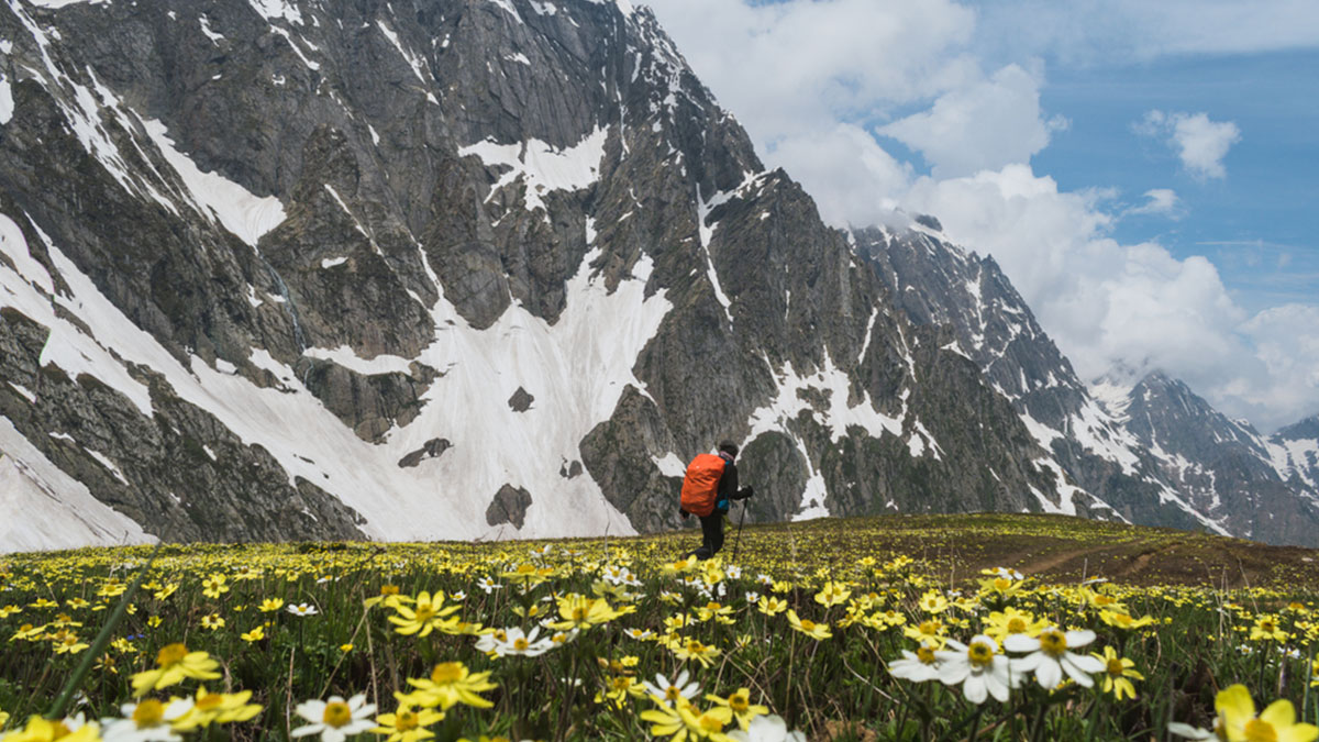
The Kashmir Great Lakes (KGL) Trek is a high-altitude Himalayan trek that traverses a series of alpine lakes, wide meadows, and mountain passes across the Kashmir Valley. It is widely considered one of the most scenic multi-day treks in India due to its constantly changing landscapes, where almost every day introduces a new lake, valley, or meadow.
The trek combines long meadow walks with multiple high-altitude passes, offering a balanced mix of physical challenge and visual reward. Unlike treks that focus on a single viewpoint or summit, the Kashmir Great Lakes Trek delivers consistent scenery throughout the route, making it a favorite among trekkers seeking a complete Himalayan experience.
Quick Facts
- Duration: 6 Nights – 7 Days
- Distance: ~68–80 km (varies based on route and campsite selection)
- Highest Point: Gadsar / Gadsar Pass area — approx. 13,700–13,850 ft (4,180–4,220 m)
- Start Point: Gagangir (Shitkadi / Shitkari base camp)
- End Point: Naranag
- Difficulty Level: Moderate to Difficult
- Suitable For: Fit beginners with preparation and prior experience; intermediate trekkers
Why Trekkers Choose the Kashmir Great Lakes Trek
The defining feature of this trek is its chain of alpine lakes, including Vishansar, Krishansar, Gadsar, Satsar, Gangabal, and Nundkol, each located in a distinct landscape. These lakes are connected by meadows, ridges, and mountain passes, creating a route that feels dynamic rather than repetitive.
The terrain varies daily — from gentle grasslands and river valleys to rocky moraines and narrow ridgelines — making the trek appealing to photographers, nature enthusiasts, and trekkers looking for variety in a single itinerary.
KGL Trek: Distance, Duration & Terrain
The KGL trek spans 7–8 days and covers approximately 70–80 km of varied terrain. The trail includes gradual ascents, rocky stretches, narrow ridges, river crossings, and high-altitude passes. Starting from Sonamarg and concluding at Naranag, the route showcases some of the most untouched regions of Kashmir.
Best Time to Do the Kashmir Great Lakes Trek
The best time to do the Kashmir Great Lakes Trek is from July to mid-September.
- July to August: Snow begins to melt, meadows turn lush green, and alpine flowers bloom.
- Late August to mid-September: Clearer skies, fewer crowds, and deeper blue lake colors — ideal for photography.
The Pir Panjal range acts as a natural rain barrier, keeping the region relatively dry even during the monsoon season compared to other Himalayan treks.
KGL Trek: Difficulty, Fitness & Acclimatisation
The trek falls under the moderate to difficult category due to long walking days, altitude gain, and multiple high passes. While it does not involve technical climbing, trekkers should be comfortable walking 6–8 hours daily at high altitude.
Good cardiovascular fitness, prior trekking experience, and proper acclimatisation are strongly recommended. Altitude-related symptoms may occur above 3,500–4,000 m, so a steady pace and hydration are essential.
Practical Information (Important for Trekkers)
- Army Check Posts & ID: The route passes through sensitive zones near Gadsar and Satsar. Original government-issued photo ID is mandatory and may be collected temporarily for verification at army/ITBP check posts.
- Network & Connectivity: Mobile network is extremely limited. Signal may be available near Sonamarg, Naranag, and occasionally at high points like Nichnai Pass. No reliable connectivity should be expected during the core trek.
- Route Variations: Total distance and daily walking hours may vary depending on the exact start point (Shitkadi vs Sonamarg roadhead) and campsite locations used by different operators.
Why This Trek Stands Out
Unlike treks that peak at a single highlight, the Kashmir Great Lakes Trek offers continuous visual rewards, with new valleys, lakes, and landscapes unfolding each day.
For trekkers looking for a Himalayan journey that combines natural beauty, changing landscapes, and a deep sense of immersion, the Kashmir Great Lakes Trek offers an unforgettable experience through the heart of Jannat-e-Kashmir.
Gallery


Itinerary
Day
Srinagar Arrival | Drive to Gagangir(70 Kms, 3 Hrs)
Day
Gagangir to Shitkadi – Trek to Nichnai via Shekdur (11 kms / 8hrs)
Day
Nichnai to Vishansar lake via Nachnai Pass (12 Kms | 7 hrs)
Day
Vishansar lake to Gadsar via Gadsar Pass (14 Kms | 8 hrs)
Day
Gadsar to Satsar (12 Kms | 6 Hrs)
Day
Satsar to Gangabal twin lakes via Zaj Pass (11 Kms | 6 Hrs)
Day
Gangabal to Naranag (11 Kms | 6 Hrs) | Drive to Srinagar
Age Limit (Trip Wise)
Weekend
Getaways
18-38
Himalayan
Treks
18-48
Backpacking
Trips
18-40
Biking
Trips
18-45
Customized
Trips
No Limit
Inclusions & Exclusions
| Inclusions | Exclusions |
Accommodation: 1 night in a homestay in Gagangir on a triple-sharing basis and 5 nights of tented accommodation on a triple-sharing basis. Transportation: Surface transfer from Srinagar to Srinagar by Sumo/Bolero or similar (non-AC), depending on the number of travelers. Note*: “Those who are booking from Gagangir to Naranag will have to bear the cost to and from Srinagar.” Meals: All veg meals from day 1st Dinner to day 7th Breakfast. Snacks: Morning / Evening Tea / Coffee with light snacks. Camping logistics: Tent, Sleeping bags, Mattresses, Dining tent, Toilet tent. Trek Leader: Qualified and Experienced Trek leader and support staff. The Trek Leader will join the group from Gagangir to Naranag. However, they will be in touch with you from the start. Permits: All necessary fees and permits. Safety Equipment: Basic First Aid kit with Oximeter and Oxygen Cylinder. Guide ratio: Local experience guide (depends on the group size). Others: Cloak Room facility available at base camp for extra luggage. | Any expenses of a personal nature. Meals during transit. Insurance of any kind. Any fees and permits (for non-Indians). Unscheduled delay due to a landslide. Cost Escalation due to “Force Majeure and Evacuation charges”. Anything not mentioned explicitly in the above program. Note: “This is for those who are not opting for the Srinagar-to-Srinagar package. The cost to and from Srinagar will be borne by the trekker.” The pick-up from Srinagar TRC will be at 11 AM. We will arrange the transportation from Srinagar TRC to Sitkari and Return from Naranag to Srinagar TRC at an additional cost of approx. ₹4000 per vehicle one way. The amount would be paid directly to the driver, and participants are expected to share the cost of the vehicle (One cab can accommodate 5-6 trekkers). Bag offloading cost is ₹3000 (maximum weight should not be more than 10 kg) Documents required for the Permits: Aadhar Card, Medical Certificate, and Travel Insurance |
Cancellation Policy
View Full Terms & Policy| Upto 21 days | 20-15 days | 14-8 days | 7-0 days | |
| Batch Shifting | ||||
| Cancellation Charge | Free Cancellation | 25% of the Trip Amount | 50% of the Trip Amount | 100% of the Trip Amount |
| Booking Amount | Refunded in mode of Credit Note | Adjusted in Refund Deduction | Adjusted in Refund Deduction | No Refund |
| Remaining Amount | Full Refund (minus) booking amount | Refund (minus) 25% of the trip amount | Refund (minus) 50% of the trip amount | No Refund |
Credit Note :
The Booking Amount will be credited to your JW Profile which can be accessed by logging in to the website through your Phone Number & OTP. Credit Notes issued have no date of expiry and can be used entirely in any of your future trips.
GST :
Any GST charged on any transaction will not be refunded.
Pending Refund :
Any refund pending on your booking will be credited to the same mode of payment through which you paid in 5-7 working days.
Partial Refund :
Any case in which a partial refund will be issued will be calculated after deducting the Booking Amount and Cancellation Charges depending on the time of Cancellation.
Remaining Amount :
Will be calculated on the amount paid over and above the booking amount.
Bypass Policy :
Any and all Cancellation Policies are superseded by the Emergency Case Cancellation Policy in case of situations such as war, pandemics, force majeure, or similar extraordinary events affecting the tour region.
Payment Policy
| Upto 21 days | 21-15 days | 14-08 days | 07-03 days | |
|---|---|---|---|---|
| Booking Amount | ||||
| 50% Payment | Optional | Compulsory | ||
| 75% Payment | Optional | Optional | Compulsory | |
| 100% Payment | Optional | Optional | Optional | Compulsory |
FAQs
Is the Kashmir Great Lakes Trek difficult?
The Kashmir Great Lakes Trek is rated Moderate to Difficult. While there is no technical climbing, the trek involves long walking days (6–8 hours), high-altitude passes, and altitude gain. It is suitable for fit beginners with preparation and experienced trekkers.
What is the best time to do the Kashmir Great Lakes Trek?
The best time to do the trek is from July to mid-September. During this period, snow clears from the passes, meadows turn green, and the lakes appear at their clearest. Outside this window, the trek remains inaccessible due to snow.
How many days does the Kashmir Great Lakes Trek take?
The trek typically takes 7 days, starting from Sonamarg (Shitkari base camp) and ending at Naranag. The total trekking distance ranges between 68–80 km, depending on route and campsite variations.
What is the maximum altitude of the Kashmir Great Lakes Trek?
The highest point on the trek is Gadsar Pass, located at approximately 13,700–13,850 ft. Proper acclimatisation and a steady pace are important to adjust to the altitude safely.
Is the Kashmir Great Lakes trek safe for travelers?
Yes, the trek is conducted with safety protocols in place. Each group is led by an experienced trek leader, supported by trained staff. First-aid kits, oximeter, and oxygen cylinder are carried. However, due to the remote terrain, trekkers must be physically prepared and follow safety instructions strictly.
Does the Kashmir Great Lakes Trek start from Sonamarg?
Yes, the trek starts from Sonamarg, with Shitkari (Shitkadi) village serving as the base camp. Trekkers assemble in Srinagar and drive to Sonamarg on Day 1 before beginning the trek.
Is network connectivity available during the trek?
Mobile network connectivity is extremely limited during the Kashmir Great Lakes Trek. Some signal may be available near Sonamarg, Naranag, or occasionally at high points like Nichnai Pass, but most of the trek has no network coverage.
Are permits required for the Kashmir Great Lakes Trek?
Yes, permits are mandatory. Indian nationals’ permits are included in the trek package. Trekkers must carry original ID proof, two photocopies, travel insurance, and a medical certificate. Army and ITBP check posts are present near Gadsar and Satsar.
What kind of accommodation is provided during the trek?
Accommodation is in tents on a twin or triple sharing basis. Sleeping bags and mattresses are provided to ensure comfort during cold nights at high-altitude campsites.
What food is provided during the Kashmir Great Lakes Trek?
All vegetarian meals are provided from Day 1 dinner to Day 7 breakfast, along with morning and evening tea or coffee and light snacks. Drinking water is sourced from natural streams and purified before consumption.
What are the Seven Great Lakes of Kashmir?
The Seven Great Lakes of Kashmir include Vishansar, Krishansar, Gadsar, Satsar, Gangabal, Nundkol, and Tarsar Lakes, famous for alpine beauty, turquoise waters, mountain scenery, meadows, camping, and trekking experiences.
When does the Kashmir Great Lakes Trek open?
The Kashmir Great Lakes (KGL) Trek for 2026 is expected to open in early July. The trekking season usually continues through July, August, and early September, offering multiple departures during this period.
Everything You Need to Know About Kashmir Great Lakes Trek
The Kashmir Great Lakes trek is considered one of the most beautiful treks in India, offering a 360° view of panorama mountains, rolling meadows, alpine lakes, and valleys. The trek is set on a canvas that's larger than life, with every day presenting a 360° panorama of wild, rugged mountains, rolling meadows, and turquoise alpine lakes.
The lakes on the trek, such as Vishansar and Kishansar, are connected, with the same water flowing in both. Interestingly, no algae formation can be found in these two lakes, which means that nothing can grow in this lake except for trout fish.
Gadsar Lake, on the other hand, appears green due to algae growth. The KGL trek is also known for its meadows, which come in every shape and size, sometimes many in a day. After this trek, every other trek feels as though it is a movie on a small screen due to its grandeur.
____________________________________________________________________________________
Kashmir Great Lakes Trek Duration & Distance
The Kashmir Great Lakes Trek is a 7-day Himalayan trek, beginning from Sonamarg (Shitkari base camp) and concluding at Naranag, with an overall trekking distance of approximately 68–80 km. The variation in distance depends on campsite locations and route conditions followed during the season.
Trekkers typically walk for 6 to 8 hours each day, covering daily distances ranging between 11 km and 14 km. The trail includes long meadow walks, steady ascents, river crossings, and high-altitude passes such as Nichnai and Gadsar.
Some days are physically demanding due to altitude gain and terrain, while others are relatively moderate, allowing time for acclimatisation and recovery.
The duration and distance of the trek are well paced, making it suitable for fit beginners with preparation as well as experienced trekkers who are comfortable with sustained walking at high altitude.
____________________________________________________________________________________
Maximum Altitude of Kashmir Great Lakes Trek
The maximum altitude on the Kashmir Great Lakes Trek is reached at Gadsar Pass, which stands at approximately 13,700 to 13,850 ft above sea level. This is the highest point trekkers cross during the journey and plays a key role in determining the trek’s overall difficulty level.
Due to the gradual but sustained altitude gain over consecutive days, proper acclimatisation and a steady walking pace are essential. While the trek does not involve technical climbing, the high altitude can cause discomfort if trekkers move too fast or do not allow their bodies enough time to adjust.
Maintaining hydration, following the trek leader’s pace, and being attentive to early altitude-related symptoms are important for a safe and comfortable trekking experience.
____________________________________________________________________________________
Kashmir Great Lakes Trek Difficulty Level
The Kashmir Great Lakes Trek difficulty is classified as Moderate to Difficult, making it suitable for trekkers who are physically fit and prepared for sustained walking at high altitude. While the trek does not involve technical climbing or mountaineering skills, it is demanding due to long walking days, altitude gain, and varied terrain.
Trekkers walk for 6–8 hours daily, covering distances of 11–14 km on certain days. The route includes gradual ascents, rocky stretches, river crossings, and high passes such as Nichnai Pass and Gadsar Pass, which add to the physical challenge. Weather conditions and altitude can further increase the effort required on some days.
This trek is ideal for fit beginners with prior trekking experience as well as intermediate trekkers. Absolute beginners or those without adequate fitness preparation may find the trek challenging. Proper acclimatisation, a steady pace, and good endurance are key to completing the Kashmir Great Lakes Trek comfortably and safely.
____________________________________________________________________________________
Best Time to Do Kashmir Great Lakes Trek
Trekking Season for Kashmir Great Lakes Trek
The Kashmir Great Lakes Trek is accessible only for a short period each year, with the best trekking season running from July to mid-September. During this window, snow melts from the high passes, trails open up, and weather conditions remain suitable for multi-day trekking.
Kashmir Great Lakes Trek in July to Early August
July marks the start of the trekking season. Snow patches are still visible near higher passes, while the valleys and meadows turn lush green with blooming alpine flowers. This period offers vibrant landscapes, though trekkers may experience occasional rainfall and cloud cover.
Kashmir Great Lakes Trek in Mid-August to Mid-September
From mid-August onwards, the weather becomes more stable with clearer skies and reduced chances of rain. The alpine lakes appear deeper in colour, visibility improves, and trekking conditions are generally more comfortable. Nights start getting colder, especially at higher camps, making warm layers essential.
Monsoon Impact on Kashmir Great Lakes Trek
The Pir Panjal range acts as a natural barrier against heavy monsoon rains, keeping the Kashmir Great Lakes region relatively dry compared to many other Himalayan treks. While light showers can occur, prolonged rainfall is uncommon during the trekking season.
Choosing the Best Time for Your Trek
Trekkers who enjoy lush meadows and seasonal flowers often prefer early season (July–early August), while those seeking clearer weather and better photography conditions usually choose late August to mid-September.
____________________________________________________________________________________
Weather & Temperature on Kashmir Great Lakes Trek
The weather on the Kashmir Great Lakes Trek varies significantly due to altitude and changing terrain. Even during the trekking season, conditions can shift quickly, making it important to be prepared for both warm and cold weather.
Day Temperature
During the day, temperatures generally range between 12°C to 20°C. Sunny conditions are common, especially from mid-August onwards, but cloud cover and light rain can occur, particularly in July and early August. Walking conditions during the day are usually comfortable when layered clothing is used.
Night Temperature
At night, temperatures drop sharply, especially at higher camps near Vishansar, Gadsar, and Satsar. Night temperatures can range between 0°C to 5°C, and may drop further during cold or windy conditions. Proper thermal layers and a good-quality sleeping bag are essential for comfort.
Overall, trekkers should expect cold mornings, pleasant afternoons, and chilly nights. Carrying waterproof clothing, warm layers, and wind protection is strongly recommended, as weather conditions in the high Himalayas can change without much warning.
____________________________________________________________________________________
Fitness Required for Kashmir Great Lakes Trek
The Kashmir Great Lakes Trek requires a good level of physical fitness due to long walking days, altitude gain, and continuous movement over varied terrain. Trekkers should be prepared to walk for 6–8 hours a day on consecutive days while carrying a daypack.
Good cardiovascular endurance is essential, as the trail involves steady ascents, high-altitude passes, and daily distances of up to 11–14 km. Leg strength and stamina play a major role, especially on days that include rocky sections, river crossings, and sustained climbs.
Prior trekking experience is strongly recommended, particularly experience above 3,000 m, as altitude can significantly affect energy levels. Trekkers should be comfortable with limited facilities, cold nights, and changing weather conditions. Regular cardio training such as brisk walking, stair climbing, cycling, or jogging before the trek helps in building the required endurance.
This trek is suitable for fit beginners with proper preparation and experienced trekkers. It is not recommended for individuals with poor fitness levels or those who have not trained adequately for multi-day trekking at high altitude.
____________________________________________________________________________________
Kashmir Great Lakes Trek Route & Starting Point
Starting Point of Kashmir Great Lakes Trek
The KGL Trek starts from Sonamarg, with Shitkari (Shitkadi) village serving as the base camp. Trekkers assemble in Srinagar and drive to Sonamarg, from where the trek officially begins.
Route of Kashmir Great Lakes Trek
The route of the Kashmir Great Lakes Trek follows a high-altitude trail that connects multiple alpine lakes and valleys across the Kashmir Himalayas. The standard route is as follows:
- Sonamarg → Shitkari (Base Camp) The trek begins with a drive from Srinagar to Sonamarg, with Shitkari village serving as the base camp.
- Shitkari → Nichnai (via Shekdur) The trail ascends gradually through forests and meadows, opening into wide alpine grasslands.
- Nichnai → Vishansar Lake (via Nichnai Pass) A high-altitude pass crossing followed by a descent into lush meadows leading to Vishansar Lake.
- Vishansar → Krishansar → Gadsar Lake (via Gadsar Pass) The route crosses the highest point of the trek, offering views of multiple lakes and snow-clad peaks.
- Gadsar → Satsar The trail moves through a series of small lakes and open valleys, leading to the Satsar region.
- Satsar → Gangabal & Nundkol Lakes (via Zaj Pass) A mix of ascents and descents leads to the twin lakes at the base of Mount Harmukh.
- Gangabal / Nundkol → Naranag A long descent through forests and meadows marks the end of the trek at Naranag.
This Sonamarg to Naranag route is the most commonly followed and provides a well-balanced progression in altitude, terrain, and scenery.
____________________________________________________________________________________
Network Connectivity on Kashmir Great Lakes Trek
Mobile network connectivity on the Kashmir Great Lakes Trek is extremely limited due to the remote and high-altitude nature of the trail. Trekkers should be prepared for long stretches without any mobile signal during the trek.
Network coverage is usually available only near Srinagar, Sonamarg, and Naranag. In some cases, weak or intermittent signals may be caught at higher points such as Nichnai Pass, but this is unreliable and should not be expected. During the main trekking days—especially around Vishansar, Gadsar, Satsar, and Gangabal—there is no network connectivity.
Electricity and charging facilities are not available during the trek. Trekkers are advised to carry power banks and inform family members in advance about limited communication. Trek leaders handle emergency communication through local networks or ground support when required.
This lack of connectivity allows trekkers to fully disconnect and focus on the experience, but proper preparation is essential to manage expectations and stay safe.
____________________________________________________________________________________
Permits & Army Check Posts on Kashmir Great Lakes Trek
The Kashmir Great Lakes Trek passes through sensitive high-altitude regions near the Line of Control (LoC), and permits along with army/ITBP verification are mandatory for all trekkers. These checks are part of the standard protocol and are handled during the trek at designated points.
Are Permits Included in the KGL Package?
Yes, all necessary fees and permits for the trek are included in our standard package. We handle the administrative work with the local authorities and the army to ensure a smooth transition through the various check-posts.
Mandatory Document Checklist
To process your permits and clear the army checkpoints, you must carry the following documents:
- Original Government ID Proof: Aadhar Card is preferred.
- Photocopies: You must carry at least 2 clear photocopies of your original ID to submit at the army camps.
- Medical Certificate: A certificate signed by a registered medical practitioner confirming your fitness for high-altitude trekking.
- Travel Insurance (Mandatory): A valid travel insurance policy is required to process your trekking permits. Please note that insurance is not included in the package and must be arranged independently.
Understanding the Army Check Post Process
The Kashmir Great Lakes trek involves multiple layers of security. Being aware of these helps maintain a transparent and stress-free journey:
- Initial Verification (Shitkari): On Day 1, your documents are submitted at the base camp check-post near Sonamarg.
- The Satsar Security Zone: This is the 3rd line of defense from the LOC. The army check-post at Satsar is one of the most critical points on the trek.
- Verification Timeline: At check-posts like Gadsar and Satsar, the army personnel record the details of every trekker and staff member. This process can take anywhere from 30 minutes to 2 hours depending on the group size.
Why Transparency Matters
We believe in full transparency regarding the security protocols of the KGL trek. While the presence of army personnel is a reminder of the region's sensitivity, it also ensures a high level of safety for all trekkers.
Carrying your Original ID and photocopies is non-negotiable; without them, the army will not permit you to proceed past the Gadsar Pass.
____________________________________________________________________________________
Food & Water Availability on KGL Trek
One of the primary concerns for trekkers heading into the high-altitude wilderness of Kashmir is the quality and availability of sustenance.
Since the KGL trek is a completely remote trail with no permanent shops or dhabas after Sonamarg, we ensure that our kitchen team is fully equipped to provide nutritious meals throughout the journey.
Daily Meal Plan (What’s Included)
Our package includes a carefully curated vegetarian menu designed for high-altitude endurance:
- Breakfast & Dinner: Served hot at the campsite. Meals typically include a mix of Indian staples like Dal, Sabzi, Roti, and Rice, along with porridge or eggs for breakfast.
- Packed Lunch: Since we are on the move during the day, we provide a nutritious packed lunch (e.g., sandwiches, parathas, or fruit) to keep your energy levels steady.
- Snacks: Morning and evening tea or coffee are served with light snacks to help you recover after a long day of trekking.
Water Sources & Safety
Water management is critical on the KGL trek. Fortunately, the trail is blessed with several fresh water sources:
- Natural Streams: You will find numerous crystal-clear streams and waterfalls cascading from the cliffs. These are the primary sources for refilling your water bottles during the trek.
- Boiled Water: We recommend filling your bottles with boiled or filtered water provided at the campsite every morning before starting the day's trek.
- Hydration Rule: We advise every trekker to carry at least two 1-liter water bottles and drink 3–4 liters of water daily to aid in acclimatization and prevent AMS.
Can I Buy Food on the Trail?
Unlike popular treks like the Everest Base Camp or Hampta Pass, the Kashmir Great Lakes trek has no permanent tea houses or shops once you leave the base camp at Shitkari.
You might occasionally find small temporary shepherd (Gujjar) huts that sell basic items like tea or biscuits, but these are not reliable. It is essential to carry your own supply of energy bars, chocolates, or dry fruits for an extra boost between meals.
____________________________________________________________________________________
Safety Measures on Kashmir Great Lakes Trek
Safety is our absolute priority on the Kashmir Great Lakes trek. While the trail offers unparalleled beauty, it also presents challenges like high altitude, unpredictable weather, and remote terrain. To ensure a secure experience for every trekker, we have implemented the following comprehensive safety protocols.
Specialized Safety Equipment (Included in Package)
We don’t just carry a standard first-aid kit; we carry life-saving equipment specifically for high-altitude environments:
- Oxygen Cylinders: Every group is equipped with a medical-grade oxygen cylinder to provide immediate relief in case of severe altitude-related respiratory issues.
- Pulse Oximeters: Our trek leaders perform regular health checks, using oximeters to monitor your heart rate and blood oxygen levels ($SpO_2$). This helps us detect early signs of AMS before they become serious.
- Comprehensive First Aid: We maintain a fully stocked medical kit for common ailments like mountain sickness, stomach issues, and minor injuries.
Expert Trip Caption and Support Staff
The safety of a trek often depends on the experience of the leader:
- Qualified Trek Leaders: Your group will be led by a qualified and experienced trek leader who is trained in wilderness first aid and high-altitude rescue protocols.
- Local Insight: We employ local support staff who possess intimate knowledge of the Kashmiri terrain, weather patterns, and "safe-zones" along the trail.
Managing Altitude Sickness (AMS)
The KGL trek involves crossing passes above 13,000 ft, making Acute Mountain Sickness (AMS) a real possibility.
- Acclimatization Built-in: Our 7-day itinerary is designed with gradual altitude gains to allow your body to adjust naturally.
- Hydration and Pace: Our guides ensure you maintain a "Pole-Pole" (slow and steady) pace and stay hydrated, which are the most effective ways to prevent AMS.
Security and Emergency Protocols
The Kashmir Great Lakes trek takes place in a high-security zone, which provides an added layer of safety:
- Army Checkpoints: The presence of multiple army check-posts (like those at Gadsar and Satsar) ensures that the trail is constantly monitored and secure.
- Evacuation Plan: In the event of a medical emergency or extreme weather, we have established evacuation protocols to move trekkers to the nearest road-head as quickly as possible.
- Force Majeure: We monitor weather forecasts daily and will not hesitate to delay a pass crossing if conditions become unsafe.
By following established safety protocols, proper acclimatisation practices, and group discipline, the Kashmir Great Lakes Trek is conducted in a controlled and responsible manner.
____________________________________________________________________________________
Who Should Do the Kashmir Great Lakes Trek?
The Kashmir Great Lakes (KGL) trek is often called the most beautiful trek in India, but it is not a leisure walk. It is a demanding high-altitude expedition that requires a specific level of preparation and mindset.
Fit Beginners with Proper Preparation
If this is your first multi-day trek, the trek is achievable provided you have a high baseline of physical fitness.
- Requirement: You should be able to jog 5 km in 30–35 minutes or walk 10 km comfortably.
- Expectation: Be prepared for steep ascents and 8-hour trekking days. If you are a "fit beginner," this trek will set a high bar for your future adventures.
For Experienced Trekkers
For those who have completed treks like Hampta Pass or Roopkund, the great lakes of kashmir trek offers a unique landscape of alpine lakes and rolling meadows that is vastly different from the rocky terrain of Himachal or Uttarakhand.
- Challenge: Crossing three high-altitude passes (Nichnai, Gadsar, and Zaj Pass) provides enough thrill even for seasoned trekkers.
Solo Travelers and Small Groups
The kgl trek is a favorite for solo trekkers who want to join a group and meet like-minded adventurers.
- Safety: Our fixed-departure batches offer a secure environment for solo travelers, with expert guides and army check-posts providing an added layer of safety along the trail.
Photography and Nature Enthusiasts
If your goal is to capture the "Heaven on Earth," this trek is for you.
- Visuals: With a new turquoise lake every day and views of the Harmukh Glacier, it is a paradise for photographers.
Who Should NOT Do This Trek? (Important)
To maintain safety and group rhythm, we recommend skipping this trek if:
- Chronic Health Issues: You have severe asthma, heart conditions, or chronic knee/hip injuries.
- Sedentary Lifestyle: You haven't engaged in any physical training or cardio in the 2 months leading up to the trek.
- Age Restrictions: You are below the age of 13 or above 60 years without a high level of active fitness.
- Short Timelines: You are looking for a weekend getaway. The kgl trek duration is a committed 7–8 day journey that cannot be rushed.
____________________________________________________________________________________
How to Reach the Kashmir Great Lakes Trek
The Kashmir Great Lakes Trek starts from Srinagar and the trekking trail begins near Sonamarg at Shitkari (Shitkadi) village. Trekkers are required to reach Srinagar first, from where transportation to the base camp is arranged.
Reach Srinagar (Base City)
Srinagar is the main gateway to the Kashmir region and is well connected to major Indian cities.
By Air (Recommended):
Srinagar Airport (SXR) has regular direct flights from Delhi, Mumbai, Bengaluru, and other major cities. This is the fastest and most convenient way to reach Srinagar.
Pro-Tip: Book a flight that lands before 9:00 AM on Day 1 to ensure you have enough time to reach our assembly point.
By Train:
The nearest major railway station is Jammu Tawi (JAT).From Jammu, you can take a shared taxi or a bus to Srinagar, which is a scenic but long 8–10 hour drive (approx. 250 km).
By Road:
Srinagar is accessible by road from Jammu via NH44. Bus and taxi services are available, though road travel can be affected by weather and landslides.
Reporting Point in Srinagar
All trekkers must report at the Tourist Reception Centre (TRC), Srinagar, by 11:00 AM on Day 1, as per the itinerary. The TRC is a central landmark in Srinagar and is easily accessible via local taxis from the airport or your hotel.
Srinagar to Sonamarg (Base Camp)
From Srinagar, trekkers drive to Sonamarg, which is approximately 90 km away and takes around 3.5 to 4 hours by road.
- The drive offers scenic views of valleys, rivers, and mountain landscapes.
- Shitkari village, near Sonamarg, serves as the base camp for the Kashmir Great Lakes Trek.
- Original ID proof and photocopies are required at army check posts during this drive.
Return Route After the Trek
The trek concludes at Naranag, from where trekkers are driven back to Srinagar. The drive takes approximately 3–4 hours, after which the group disassembles.
Trekkers are advised to plan onward travel from the next day to account for any unforeseen delays due to weather or road conditions.
Important Travel Tips
- Keep original ID proof, photocopies, medical certificate, and travel insurance handy during travel.
- Avoid booking early morning return flights on the last day.
- Weather conditions in Kashmir can impact road travel; buffer time is strongly recommended.
Why Choose JustWravel for Kashmir Great Lakes Trek
Choosing the right trek is easy, but selecting the right trekking company is the real challenge—especially when venturing into the remote areas of the Himalayas. The experience and credibility of a trekking organization are crucial factors you need to consider. We understand these concerns, and that’s why we want to show you why JustWravel is your ideal trekking partner for the Kashmir Great Lakes Trek.
Put on your Shark Tank sunglasses, because after our pitch, you'll be eager to pack your bags for the great lakes of Kashmir trek!
- The Safest Travel Community in India: For us, safety comes first. The fun, adventure, and thrill of the trail only matter if you are in safe hands.
- From the Mountains with Love: Yes, that’s us. Most of our trekking coordinators are from the mountains; they share year-round knowledge of how pahadi life is. Nobody knows the mountains better than the people who have grown up playing on its slopes. Most of our local guides and vendors are also natives, which assures an exchange of healthy and profitable business on both ends.
- Certified Trek Captains: Our Trek Captains are both BMC and AMC (Advanced Mountaineering Course) certified. They are also highly skilled medics who know every nook and cranny of the trail, equipped to handle any situation.
- The Experience of Years: Our knowledge is not merely theoretical. We’ve spent years in these mountains, learning valuable lessons that we pass on to every trekker who joins us.
- Taking What We Took There: This is what sets us apart in the market. We never litter. What we bring into the mountains, we take back. This commitment is the foundation of our Keep The Trails Alive campaign.
Our Heart: The ‘Keep The Trails Alive’ Initiative
Don’t be a Crap Bag You are in nature’s lap Kindly take that garbage back
If you’re wondering what our "Keep the Trails Alive" campaign is all about, it’s simple: without proper management, many sacred mountains face the threat of over-tourism. As responsible trekkers, we won’t let that happen.
If you’re trekking to Kashmir Great Lakes Trek with JustWravel, you ensure that everything you carry in, you carry out. We leave nothing behind except our love and a piece of our hearts.
Our Sustainability Standards:
- Reusable Only: We encourage carrying your own water bottles and cutlery to minimize waste.
- Carry Out What You Carry In: All waste—food wrappers, bottles, tissues—must be packed out. We never burn waste in the mountains.
- Eco-Sanitation: We use deep-pit toilet tents (6+ inches) to ensure zero contamination of local water sources.
- Respecting Wildlife: We manage food waste carefully and never feed wildlife to prevent dependency.
- Water Protection: We wash dishes and ourselves far away from streams and lakes, using only biodegradable soap sparingly.
The JW Standards: Everything You Need to Know
Trekking at Kashmir Great Lakes altitude of 13,750 ft requires specific standards. Here is how we manage the ground reality:
Acclimatization & Safety
Acclimatization is the critical process of letting your body adjust to lower oxygen levels. We follow a gradual ascent (300-500 meters per day above 3,000m) and incorporate rest days. Staying hydrated (3-4 liters daily) and a carbohydrate-rich diet are essential to prevent altitude sickness.
Logistics: Dry Pits & Bathing
- Dry Pits: In remote areas without plumbing, we use deep-hole systems that facilitate natural decomposition. This improves hygiene and protects water sources from contamination.
- Bathing: While it sounds appealing, bathing is discouraged at high altitudes. Cold water can lead to rapid heat loss and hypothermia. Save the celebratory bath for the base camp where conditions are safer.
Mountain Ethics: Food & Fire
- Vegetarian Food: We serve nutritious, energy-dense vegetarian meals. They have a longer shelf life, are easier to prepare in remote zones, and—most importantly—do not attract dangerous wildlife like bears to the campsite.
- No Bonfires: To prevent deforestation and habitat destruction, bonfires are typically prohibited. Removing wood disrupts local ecosystems, and smoke can draw animals closer to our tents.
Prepared for the Unexpected: Plan B & C
Mountain weather is unpredictable. Whether it’s a sudden storm or an emergency, we always have contingency plans. Our experienced guides use their deep understanding of the mountains to assess conditions effectively, ensuring you remain safe and comfortable no matter what challenges arise.

VIDEOS
Memories for Life
posts
Instagram Images
REVIEWS
What our Clients Say About Us
swetha kulkarni
It was my first ever trek and I chose Kashmir great lakes trek with Just Wravel. I have to say it was a fulfilling and memorable experience for me. Being a first timer , I had my own share of challenges, Major props to m...

Kashmir Great Lakes Trek
Try YourselfAnurag Bhardwaj
The Kashmir Great Lake Trek with Just Wravel was an absolute dream come true. Words can't fully capture the emotions I felt while exploring the mesmerizing landscapes and immersing myself in the local culture. This journ...
Kashmir Great Lakes Trek
Try YourselfAman Agrawal
I recently embarked on the epic Kashmir Great Lakes trek with these adventure wizards, and it was like stepping into a real-life fairy tale. The team at Justwravel knows how to throw a party in the wilderness! From the j...
Kashmir Great Lakes Trek
Try YourselfAbhishek Tawani
Awesome experience with Just Wravel team and specially Vishal Bhai who helped us throught the treck.. The Kashmir Great Lake treak is a life changing experience.. It was my first treck and very special experience, all 17...
Kashmir Great Lakes Trek
Try Yourselfjoydeep sen
KGL is my life time memory and Harish our guide make this journey to next level ...Thankyou Harish for your support and guidence
Kashmir Great Lakes Trek
Try YourselfShruthi Chitrigemath
I recently had the pleasure of embarking on an incredible journey and it was my first trek with Justwravel and had an amazing experience. Everything was so organised right from the stay even though we were staying in a t...
Kashmir Great Lakes Trek
Try YourselfDipen Shah
Overall experience with JustWravel for Kashmir Great Lakes(KGL) Trek was awesome. The way in which the group was managed, food, campsite and it�s location was very nice. Last but not the least, Trek Lead Mr. Vishal Tiwar...
Kashmir Great Lakes Trek
Try YourselfShubham Patel
I recently embarked on the breathtaking "Kashmir Great Lakes" trek with the incredible team at JustWravel, and I can't express how exceptional the entire experience was. From start to finish, this trek was nothing short...
Kashmir Great Lakes Trek
Try YourselfJyoti Verma
Had taken the Kashmir Great Lakes trek with JustWravel. It was my first trek and truly an amazing experience. It was a group of 17 people and all were really nice and friendly, specially our trek lead(Vishal) who made su...
Kashmir Great Lakes Trek
Try YourselfAkankshya Mishra
I went with JustWravel for my very first major trek- Kashmir Great Lakes. The trek leader, Vishal was extremely helpful and friendly and made sure we had the best time. The local guide- Majeed Chacha- ensured that trekke...
Kashmir Great Lakes Trek
Try Yourselfblogs
Our Blogs


TRIPS
Related Trips


B-42, 2nd Floor, Tower- B, The Corenthum, Block A, Sector 62, Noida, Uttar Pradesh 201301
© 2015-2026 JustWravel Pvt. Ltd.
Contact Us
B-42, 2nd Floor, Tower- B, The Corenthum, Block A, Industrial Area, Sector 62, Noida, Uttar Pradesh 201301
© 2015-2026 JustWravel Pvt. Ltd.
Starts From
₹ 19,500
₹ 18,500 +5% GST