


Baralacha La is a high mountain pass in the Zanskar range of the Ladakh region. It is located along the Leh-Manali Highway, connecting the Leh district in Ladakh with the Lahaul district in Himachal Pradesh.
The name Baralacha La means “pass where many roads meet.” Spanning 8 km, it is also called the “Pass with Crossroads on Summit” since roads from Zanskar, Ladakh, Spiti, and Lahaul meet at this point.

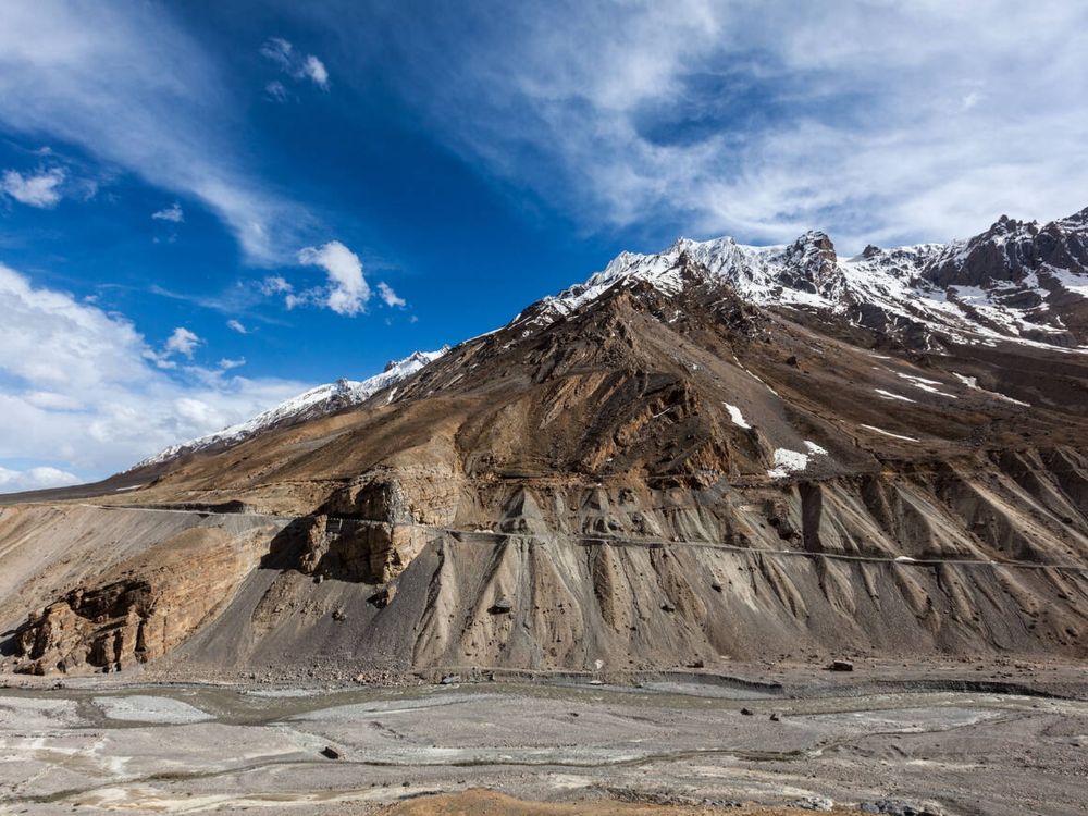
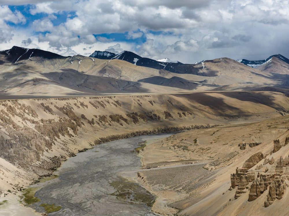
Situated at an altitude of 16,040 feet, the pass is known for its rugged and unpredictable landscapes. It presents a formidable challenge for adventurers, trekkers, and motorcyclists seeking a thrilling experience in the Himalayas.
Places to Visit Near Baralacha La
Suraj Tal
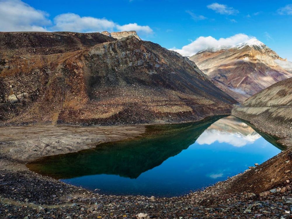
It is located just below Baralacha La, Suraj Tal is India’s third-highest lake and the source of the Bhaga River. Its crystal-clear blue waters reflect the surrounding snow-capped peaks, making it a breathtaking spot for photography and nature lovers.
It is known as the “lake of the Sun God”, the lake is known for its crystal clear waters. Suraj Tal is the source of the Bhaga river, which is a major tributary of the Chenab.
Deepak Tal
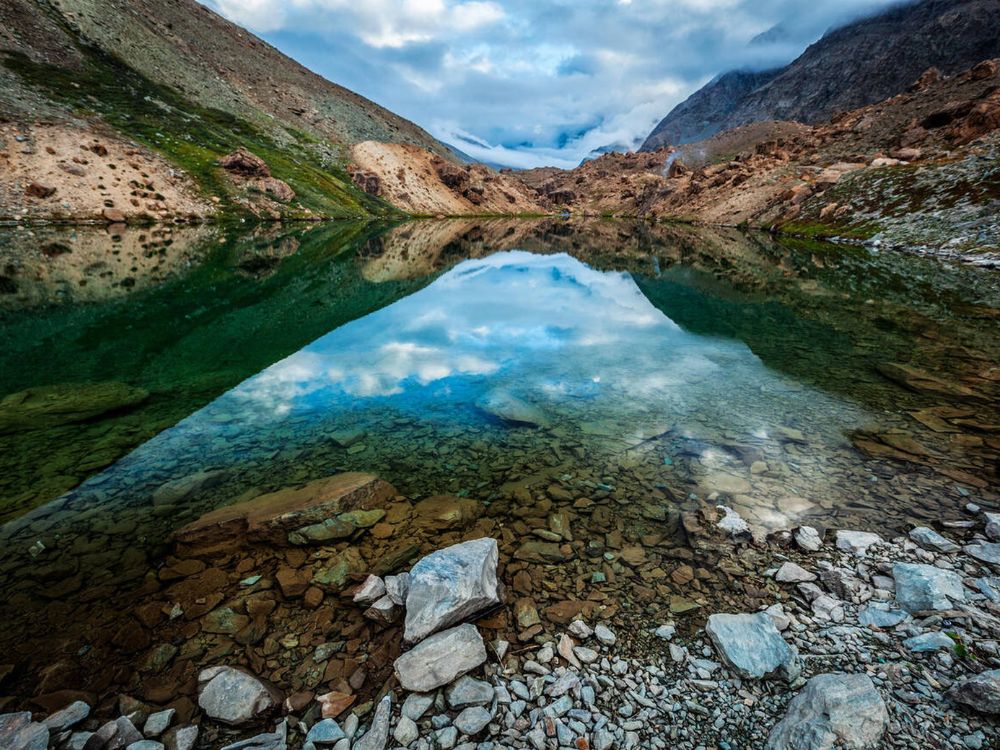
A serene glacial lake near Baralacha La, Deepak Tal is known for its tranquil beauty and pristine surroundings. It is a high-altitude lake situated at an altitude of 3,760 meters.
It’s a lesser-known gem, perfect for those seeking solitude amidst nature. It’s situated on the route between Manali and Leh, approximately 45 kilometers from Keylong. It is one of the best places to visit near Keylong.
Sarchu
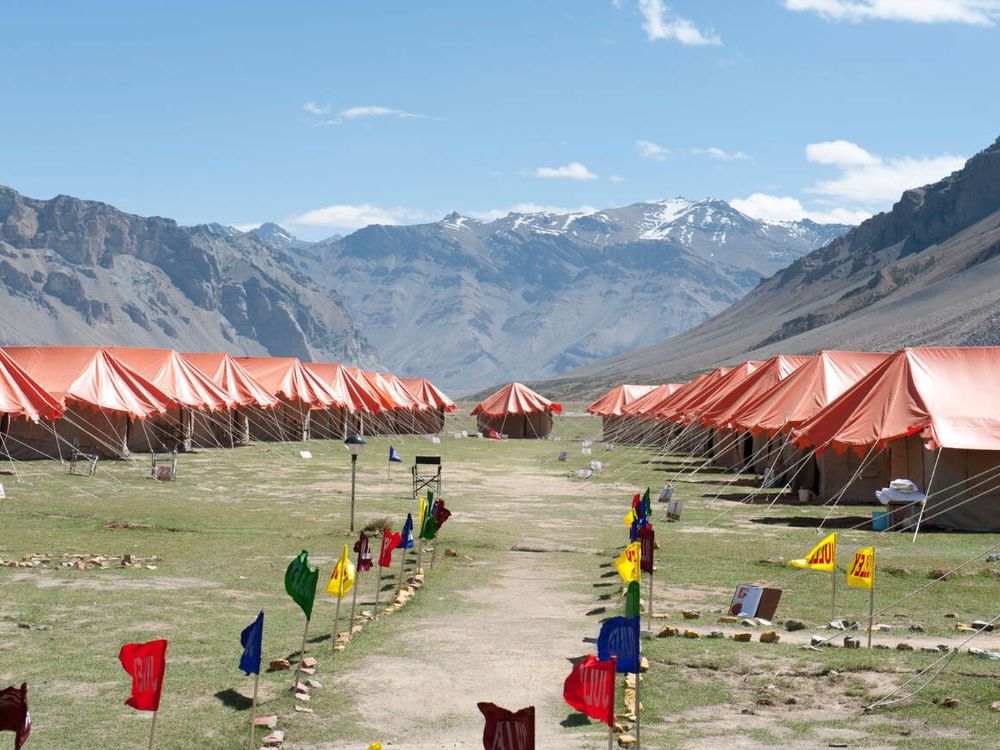
Sarchu is a high altitude plateau between Himachal Pradesh and Ladakh, Sarchu is a popular camping destination. Its vast, barren landscapes and starry nights make it a favorite among adventurers and bikers.
Sarchu holds significant importance primarily because it is located along the Leh-Manali Highway. Its stark, rugged beauty closely resembles the landscapes of Ladakh. Sarchu offers temporary night stay accommodations such as camps for visitors going to Leh, where they can stay for a night and continue their journey the following day.
Zing Zing Bar
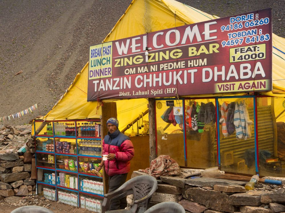
Zing Zing Bar is a scenic camping site and a teahouse way station located on the Leh-Manali highway in Lahaul and Spiti district of Himachal Pradesh. It is surrounded by rugged mountains and offers a peaceful stopover for travelers going to Ladakh via Baralacha La.
It’s an ideal spot to rest and soak in the Himalayan vistas. The place has a temporary shelter and dhabas that can be used by tourists for accommodation. Zing Zing bar is situated at a distance of 125 km from Manali.
Pang
A small settlement on the Leh-Manali route, Pang is known for its unique landscapes, including the famous More Plains, a vast, flat stretch surrounded by mountains. It’s a surreal experience to drive through this area.
Pang is another place that you will cross on the Manali-Leh highway where you will get temporary settlement and can be a good stopover for your Ladakh trip.
Keylong
The administrative center of Lahaul Valley, Keylong is a picturesque town with monasteries, apple orchards, and stunning views of the Chandra and Bhaga rivers. It’s a great place to explore local culture and history.
Jispa
A charming village on the banks of the Bhaga River at an altitude of 10,500 ft. Jispa is known for its lush greenery and tranquil ambiance. It’s a perfect stop for acclimatization and enjoying the river’s beauty.
Jispa also serves as the perfect halt for travelers on the long journey to Ladakh. There are a range of accommodations including homestays, camps and hotels; it provides a comfortable resting point for tourists making their way to Leh.
Leh

Leh, the capital of Ladakh, is a hub of culture, history, and adventure.There are plethora of places to visit in Leh such as the ancient monasteries like Hemis and Thiksey monastery. You can also explore the Leh Palace, Shanti Stupa, Hall of Fame, Magnetic hills, Gurudwara Pathar Sahib and enjoy the vibrant local markets.
These destinations near Baralacha La offer a mix of adventure, spirituality, and natural beauty, making them must-visit spots for travelers exploring the Ladakh region.
How to Reach Baralacha La
By Road
The most common and scenic route to reach Baralacha La is via the Leh-Manali Highway, which serves as the lifeline connecting Manali in Himachal Pradesh to Leh in Ladakh. The pass is strategically located approximately 190 km from Manali and about 220 km from Leh.
From Manali to Baralacha La
The journey from Manali to Baralacha La covers a distance of approximately 190 km (if traveling via the traditional Rohtang route). The typical route flow is:
Manali → Rohtang Pass → Gramphu → Keylong → Jispa → Darcha → Zing Zing Bar → Baralacha La
The road is steep, narrow, and challenging. Travelers must navigate high-altitude terrain and numerous sharp hairpin turns that require expert driving skills.
From Leh to Baralacha La
The distance between Leh and Baralacha La is approximately 220 km. This route is famous for its surreal beauty and high-altitude desert landscapes. The route flow is:
Leh → Upshi → Rumtse → Pang → Sarchu → Baralacha La
This journey is a visual treat as it passes through the iconic More Plains—a 40 km stretch of perfectly level road at 15,000 feet—and crosses the mighty Tanglang La Pass, one of the highest motorable passes in the world.
By Air
The nearest airport to Baralacha La is Bhuntar Airport (Kullu-Manali), which is located about 50 km from Manali. Once you land at Bhuntar, you can easily hire a taxi or take a bus to reach Manali, and then continue your journey to the pass by road.
Another option is to fly into the Leh Airport. From there, you can travel to Baralacha La by driving along the Leh-Manali Highway.
By Bike or Self-Drive
Baralacha La is a dream destination for bikers. Because the route is remote and tough, you must ensure your vehicle is in excellent condition. If you prefer a planned adventure with backup support, many enthusiasts join a professional Delhi to Leh bike trip with Umling La to cover this iconic pass safely.
Baralacha La Height and Features
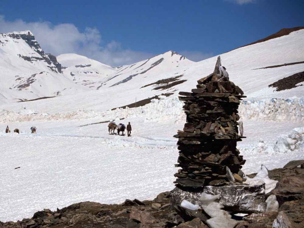
The Baralacha La pass is located at a height of 16,040 feet (4,890 meters) above sea level. It is one of the highest roads in the Indian Himalayas that you can drive on.
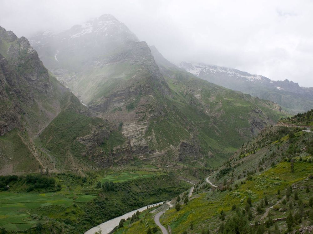
Sitting on the Leh-Manali Highway, it acts as a bridge between Himachal Pradesh and Ladakh. The pass offers incredible views of snow-covered mountains, deep valleys, and glacial lakes.
Reaching the pass is an exciting challenge for trekkers and bikers because of the steep climbs, rough roads, and sudden changes in weather. Because of its high altitude, it serves as a gateway to some of the most beautiful sights in the region, such as Suraj Tal Lake and the starting point of the Chandra River.
Best Time to Visit Baralacha La
The best time to visit Baralacha La is from June to September. This is the only window when the pass is officially open and safe for travelers.
Summer (June to September)
This is the peak season because the weather is mostly stable and pleasant. During these months, the thick snow on the pass begins to melt, making the roads accessible. The Leh-Manali Highway, which is the main route, opens during this time for cars, bikes, and trekkers.
As the snow clears, you can see lush green valleys, beautiful blooming flowers, and clear blue skies with amazing views of the Himalayas. It is the perfect time for trekking, biking, and camping because all routes are open.
Winter (October to May)
During these months, Baralacha La is completely closed to tourists. The pass remains buried under heavy snow, and the weather is extremely harsh. Temperatures often drop to -20°C or even lower, making it impossible to travel. The roads stay shut due to the high risk of avalanches and freezing conditions, so travel is not allowed during this period.
Best Itinerary for Visiting Baralacha La
If you want to experience the best of Ladakh, including Baralacha La and the world’s highest motorable roads, this itinerary is the perfect choice. This route is often followed during a Leh Ladakh bike trip from Srinagar with Hanle and Umling La, ensuring you see every major landmark.
- Day 1: Delhi to Manali (Overnight Journey) – Start your adventure with an overnight Volvo bus or private cab journey from Delhi to the mountains of Manali.
- Day 2: Manali Arrival & Exploration – Arrive in Manali, check into your stay, and spend the day exploring local spots like Hadimba Devi Temple and Old Manali to get used to the mountain air.
- Day 3: Manali to Sarchu (177 km) via Baralacha La – This is the most important day. You will travel through the Atal Tunnel and cross the mighty Baralacha La (16,040 ft) before reaching the high-altitude campsites of Sarchu.
- Day 4: Sarchu to Leh (230 km) via Gata Loops – Drive through the famous 21 hairpin bends of Gata Loops and cross several high passes like Nakee La and Lachung La to reach the heart of Ladakh, Leh city.
- Day 5: Leh to Nubra Valley (130 km) via Khardung La – Travel from Leh to the high-altitude cold desert of Nubra Valley, crossing Khardung La, which was once the highest motorable road in the world.
- Day 6: Nubra Valley to Turtuk & Back (170 km) – Visit the last village of India on this route, Turtuk. Explore its unique Balti culture before returning to your camp in Nubra Valley.
- Day 7: Nubra Valley to Pangong Lake (180 km) – Drive along the Shyok River to reach the stunning blue Pangong Tso, where you can enjoy a beautiful sunset by the lakeside.
- Day 8: Pangong to Leh (150 km) via Chang La – Head back to Leh city by crossing the steep Chang La pass. Spend your evening shopping at the Leh Main Market.
- Day 9: Leh to Kargil (216 km) via Magnetic Hill – Start your journey towards Srinagar. On the way, visit Magnetic Hill, Sangam, and cross the Fotula Pass and Namika La to reach Kargil.
- Day 10: Kargil to Srinagar (204 km) via Zoji La – On the final leg of the road trip, visit the Dras War Memorial and cross the challenging Zoji La pass to enter the beautiful valley of Srinagar.
- Day 11: Departure from Srinagar – Your epic Himalayan journey ends here. You can fly out from Srinagar Airport with amazing memories of the mountains.
Important Travel Tips for Baralacha La
If you are planning to cross Baralacha La, follow these essential tips to ensure a safe and smooth journey:
- Health and Altitude Safety: It is very important to stay hydrated by drinking plenty of water. Avoid drinking alcohol as it can make altitude sickness worse. Make sure to give your body time to get used to the high altitude by staying overnight in Jispa or Sarchu before you attempt to cross the pass.
- Fuel Up at Tandi: Remember that the last fuel station before Baralacha La is located in Tandi (near Keylong). There are no petrol pumps for a long distance after this point, so make sure to fill your tank and carry extra fuel if needed.
- Carry a Medical Kit: Always keep a basic medical kit with you. This should include an AMS (Acute Mountain Sickness) Kit, pain relievers, and medicines like Diamox (after consulting a doctor). If possible, carry a small portable oxygen cylinder for emergencies.
- Pack Proper Clothing: Even in the middle of summer, the weather at the pass can be freezing. You should pack multiple warm layers, a high-quality windproof jacket, and heavy gloves to protect yourself from the cold winds.
- Start Your Journey Early: It is best to start your drive early in the morning. In the afternoon, the sun melts the snow, which creates “slush” (muddy snow) and small streams on the road, making it hard to drive. Be very careful of icy patches and steep drops, especially during the early summer months.
- Plan Your Stay: There are absolutely no hotels or guest houses at the Baralacha La pass itself. Most travelers find stay options in nearby areas like Jispa, Sarchu, or Keylong, which offer camps and basic guest houses.
- Travel Safely: It is always safer to travel in groups or with at least one other vehicle. Also, make sure to inform a friend or family member about your route and expected time of arrival, as mobile network is very weak or unavailable in this region.
FAQs
Baralacha La is a high-altitude mountain pass located in the Lahaul and Spiti district of Himachal Pradesh. It sits at an elevation of 16,040 feet (4,890 meters) above sea level on the Leh-Manali Highway.
Baralacha La serves as a vital link between the Lahaul Valley in Himachal Pradesh and the Ladakh Union Territory. It is a key gateway for travelers moving between Manali and Leh.
Yes, Baralacha La is famous for having snow almost throughout the year. Even in peak summer months like June and July, you can find huge snow walls and frozen patches along the road, making it a favorite spot for tourists who want to see snow.
The Chandra River, which is a main part of the Chenab River, starts from the glacial melts near Baralacha La. The beautiful Suraj Tal Lake, one of the highest lakes in India, is also located just below the summit of the pass and acts as a source for the Bhaga River.
It can be challenging because of the steep climbs, narrow roads, and unpredictable weather. During early summer, “water crossings” (nallas) created by melting snow can make driving difficult for small cars. It is recommended to cross the pass before noon to avoid heavy water flow and slush.
The name Baralacha means “pass where many roads meet.” Historically, it was a junction where paths from Zanskar, Ladakh, Spiti, and Lahaul met. It was also an important part of the ancient Silk Route used by traders.